Look at the wind, not only the rain.
The causeway has little shelter. Strong west or southwest wind changes the effort more than most of the route profile.
Te Atatū → Karangahape Road
The western commuting spine. Most of the journey is separated from traffic, with an open causeway in the middle and a steady climb into the city.
WEST TO EAST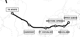
An indicative profile sampled at five points. It shows the shape of the ride, not a turn-by-turn elevation total.
Join beside the motorway interchange. Check the path direction before entering the first long section.
The path is flat and exposed. A westerly helps toward the city and becomes the work on the ride home.
Stay alert at road crossings. Carrington Road construction is underway and includes a new raised crossing.
This is the practical rail fallback. From here the route starts gaining height toward the city.
The separated route reaches the Karangahape Road area. Continue via the city network according to your final address.
The causeway has little shelter. Strong west or southwest wind changes the effort more than most of the route profile.
Construction is underway. Check the current project page before relying on the usual crossing or lane arrangement.
The sampled profile rises from about 23 metres at Kingsland to about 63 metres near Upper Queen Street.
Leave the path near Kingsland and use the Western Line. Bikes travel free when space permits. Use the middle carriage and avoid peak services when possible.
Auckland Transport lists a Fixit station at the Carrington Road entrance to the path for simple adjustments and inflation.
A workshop at 29 East Street, Eden Terrace, useful once the route reaches the city side.
Distance follows 13.1 km of named Northwestern Path features in Auckland Transport’s cycle network data. Conditions and access can change.